
AI & Automation, Drone to GIS, GIS Insights, Map Analysis, Spatial Analysis
Drone surveys produce hundreds of raw, overlapping photos that are useless until they’re stitched, georeferenced, and turned into maps a professional can measure on. Doing that traditionally means expensive desktop photogrammetry software, a powerful workstation, GIS expertise, and hours of manual work per flight.
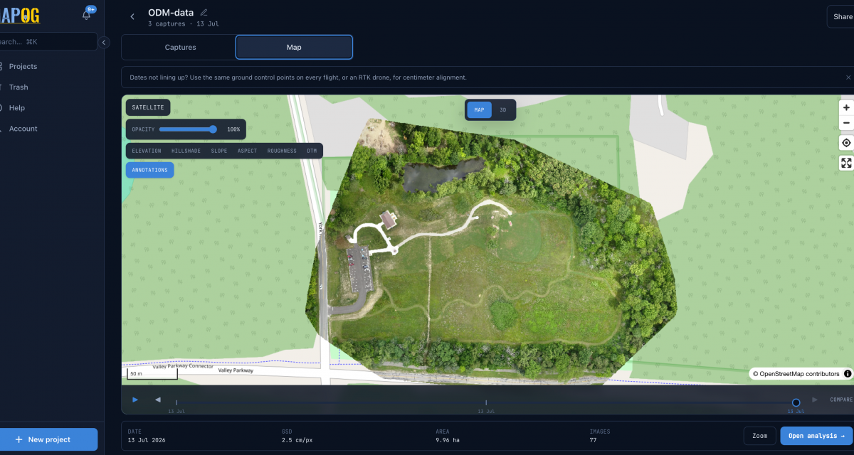
We built a web-based drone mapping platform that automates the whole journey. A user uploads a flight, presses one button, and gets back a seamless georeferenced orthomosaic, elevation models (DSM/DTM), a 3D point cloud, a textured 3D mesh, and terrain analytics — viewable on an interactive map and downloadable for GIS use. Processing runs on auto-scaling cloud infrastructure, so no local hardware is required, and the system is engineered to never lose a job even through crashes, restarts, or infrastructure failures.
Drones have made aerial data capture cheap and fast. But the data that comes off a drone is not a map — it’s a folder of hundreds of individual JPEGs, each with a slightly different angle and an imprecise GPS tag. Between that raw folder and something a surveyor, engineer, or planner can actually use sits a hard technical problem: photogrammetry.
To turn those photos into a usable deliverable, you have to:
In practice, teams hit the same walls over and over:
The core question we set out to answer: How do we let anyone turn a drone flight into professional, georeferenced mapping output — with no desktop software, no workstation, and no photogrammetry PhD — and make it fast, reliable, and shareable?
We built MAPOG’s drone mapping platform: a mobile-first web application (installable as a PWA) that acts as a complete orchestration and delivery layer around a best-in-class photogrammetry engine.
The user experience is deliberately simple:
Create a project → upload a flight → press “Start processing” → get a full mapping deliverable.
Everything hard happens invisibly behind that button. Under the hood, the platform manages authentication, uploads, a fair processing queue, live progress, cloud compute that scales on demand, result post-processing, private tile serving, an interactive viewer, analytics, and secure sharing.
Crucially, all the heavy photogrammetry is delegated to OpenDroneMap (NodeODM) — the proven open-source engine — while our platform provides everything around it that turns a raw engine into a dependable product: the web app, the job lifecycle, the auto-scaling infrastructure, the resilience, the analytics, and the collaboration layer.
From a single flight, the platform produces a complete product set:
| Deliverable | What it is |
|---|---|
| Orthomosaic | A seamless, georeferenced Cloud-Optimized GeoTIFF (COG) — the core “map” |
| DSM & DTM | Digital Surface and Terrain Models — elevation with and without objects |
| Point cloud | A dense 3D point cloud (LAZ) plus a streaming octree for the web |
| 3D mesh | A textured 3D-Tiles model of the site |
| Terrain layers | Slope, aspect, roughness, hillshade, and contours |
| Reports & exports | Branded PDF reports and GeoJSON / CSV / DXF / KML / SHP exports |
All of it is viewable directly in the browser on an interactive map and 3D viewer — nothing to install.
Users choose a quality preset instead of wrestling with dozens of parameters:
An advanced option lets power users override resolution or toggle specific outputs, but nobody has to.
The platform models real-world surveying:
The map view is temporal: a single map with a date slider whose ticks are spaced by the real gaps between flights. Users can scrub between dates, compare two dates side-by-side with a swipe, and play back a site’s evolution. New flights appear on the timeline automatically, in correct chronological order — even if an older date is uploaded later. This makes month-over-month monitoring — construction progress, mining stockpiles, agriculture, erosion — a first-class workflow instead of a manual chore.
Beyond the base map, the platform includes professional analysis tools that run right in the browser:
Advanced modules (multispectral, AI object detection, BIM, thermal) are feature-flagged and ship off by default, so the platform stays lean and enables capabilities only where needed.
Results don’t have to leave the platform as giant files. Owners can:
Sharing is enforced entirely on the server (hiding buttons is never the security control), with unguessable tokens, rate-limiting, and near-instant revocation — disable a link and its map tiles stop resolving within a minute.
(For the technically curious. Skip to “Results” if you just want the outcome.)
Rather than reinventing photogrammetry, we treat OpenDroneMap/NodeODM as the compute engine and focus our engineering on everything that makes it usable and reliable at scale: the API, the job lifecycle, storage, progress streaming, the viewer, analytics, and — most importantly — resilience and elastic compute.
Photogrammetry is bursty: idle most of the time, then it needs a lot of RAM and CPU for a couple of hours. To handle that economically, the platform uses ClusterODM with on-demand autoscaling: when a job starts, it spins up a dedicated cloud processing droplet, runs the job there, and tears the droplet down the moment it finishes — so compute cost tracks actual usage instead of a workstation sitting idle. The processing tier is sized intelligently based on the job’s preset and image count, and a GPU-accelerated processing path is available for heavier workloads.
This is where a lot of the hard work went. Long-running cloud jobs fail in messy ways — networks blip, containers restart, droplets get reaped, memory runs out. The platform is built so that none of that loses a completed result:
The result of all this engineering is a system that behaves like infrastructure, not a demo: it keeps its promises even when the underlying cloud misbehaves.
The platform delivers on the goals we set out with:
Drones made capturing aerial data effortless. This platform makes using it effortless too — closing the gap between a folder of raw photos and a professional, georeferenced, analyzable map. By pairing a proven open-source photogrammetry engine with a carefully engineered orchestration layer — elastic cloud compute, crash-proof job handling, rich in-browser analytics, and secure collaboration — we turned a slow, expensive, expertise-heavy process into a one-click web workflow that scales.
The outcome is a platform that lets organizations get survey-grade mapping and 3D intelligence from their drone flights without buying software, building a workstation, or hiring a photogrammetry specialist — just upload, click, and map.
Leave a Reply